


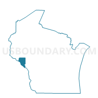
MILTON - T 1 Voting District, Buffalo County, Wisconsin
About
Outline

Summary
| Unique Area Identifier | 692550 |
| Name | MILTON - T 1 Voting District |
| County | Buffalo County |
| State | Wisconsin |
| Area (square miles) | 29.54 |
| Land Area (square miles) | 21.71 |
| Water Area (square miles) | 7.83 |
| % of Land Area | 73.49 |
| % of Water Area | 26.51 |
| Latitude of the Internal Point | 44.17587040 |
| Longtitude of the Internal Point | -91.75600870 |
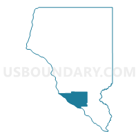
Maps

Graphs
Select a template below for downloading or customizing gragh for MILTON - T 1 Voting District, Buffalo County, Wisconsin


Neighbors
Neighoring Voting District (by Name) Neighboring Voting District on the Map
- BELVIDERE - T 1 Voting District, Buffalo County, WI
- Buffalo City - C 1 Voting District, Buffalo County, WI
- CROSS - T 1 Voting District, Buffalo County, WI
- Fountain City - C 1 Voting District, Buffalo County, WI
- Minneiska Voting District, Winona County, MN
- Minneiska City Voting District, Wabasha County, MN
- Mount Vernon Twp. Voting District, Winona County, MN
- Rollingstone Twp. Voting District, Winona County, MN
- WAUMANDEE - T 1 Voting District, Buffalo County, WI
Top 10 Neighboring County Subdivision (by Population) Neighboring County Subdivision on the Map
- Buffalo City city, Buffalo County, WI (1,023)
- Fountain City city, Buffalo County, WI (859)
- Rollingstone township, Winona County, MN (701)
- Milton town, Buffalo County, WI (534)
- Waumandee town, Buffalo County, WI (472)
- Belvidere town, Buffalo County, WI (396)
- Cross town, Buffalo County, WI (377)
- Mount Vernon township, Winona County, MN (273)
- Minneiska city, Wabasha County, MN (61)
- Minneiska city, Winona County, MN (50)
Top 10 Neighboring Place (by Population) Neighboring Place on the Map
Top 10 Neighboring Unified School District (by Population) Neighboring Unified School District on the Map
Top 10 Neighboring State Legislative District Lower Chamber (by Population) Neighboring State Legislative District Lower Chamber on the Map
Top 10 Neighboring State Legislative District Upper Chamber (by Population) Neighboring State Legislative District Upper Chamber on the Map
Top 10 Neighboring 111th Congressional District (by Population) Neighboring 111th Congressional District on the Map
Top 10 Neighboring Census Tract (by Population) Neighboring Census Tract on the Map
- Census Tract 6701, Winona County, MN (7,451)
- Census Tract 4902, Wabasha County, MN (3,397)
- Census Tract 9605, Buffalo County, WI (3,280)
- Census Tract 9604, Buffalo County, WI (2,518)